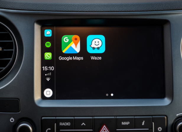
- Waze is good if you’re driving a car somewhere and need navigation, real-time alerts, and parking.
- Google Maps has more information about destinations, covers more modes of transport, and works offline.
- If you just want to get from A to B as fast as possible, Waze is the winner — but only just.
- If you want more options, Google Maps is your go-to.
- Both work on Apple Carplay and Android Auto.
- Both work on desktop and on mobile.
Waze vs. Google Maps: which one is better? It’s a debate as old as navigation apps.
In truth, if you just want to get from point A to point B, both Google Maps and Waze will get you to your destination.
But we use navigation apps for a lot more than just point-to-point directions. What if you want to add a few pit stops to your route, or find parking options, or use the app offline? That’s where the differences between Google Maps and Waze really show.
I took both apps for a test drive to see which is best for a bunch of different scenarios. Here’s what I discovered:
If you want real-time traffic alerts: Waze
Waze’s crowd-sourced nature makes it a clear winner for traffic data. Users report happenings on the road, so you know what to expect at every step of the way.
Waze users will alert you to more than just the odd traffic jam. You’ll also get warned about things like:
- Road closures
- Speed traps
- Speed cameras
- Crashes
- Lane closures
If traffic conditions change, Waze will automatically find a different route to get you to your destination ASAP.
Google Maps also has traffic updates, but they’re surprisingly sluggish for allegedly real-time data — and re-routing isn’t automatic. If you miss any of the notifications, you may wind up stuck on the same, slow route.
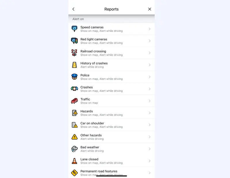
Some people complain that Waze gives too much information, and that constant voice alerts while driving can be distracting. If you don’t want all the distractions, you will need to go into your settings, and turn off alerts for each kind of report individually.
Relying on crowd-sourced data also means that there will sometimes be false reports.
If you want to find parking: Waze
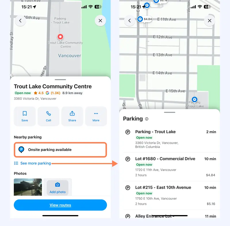
When you search for a destination on Waze, it will automatically suggest good places to find parking. It even shows prices!
Google doesn’t have this feature at all, which can add a lot of time to your journey if you end up driving around looking for somewhere to park.
On the other hand, once you’ve parked your car you may need to walk to your final destination – in which Waze has got nothing for you! You’ll need to open Google Maps to get walking directions.
If you want to use voice commands: Tie
Both apps — Waze and Google Maps — will work on an iOS device or an Android phone. And you can use voice commands on both app or device for hands-free navigation.
But the way you use voice commands will differ a little bit:
- If you’re on an Android device, all you have to do is say, “Hey Google,” and start asking for directions.
- If you’re on an iPhone, your commands have to be a little more specific. Unless you say “directions home with Waze,” Siri may use Apple Maps to get you home.
In my opinion, there really isn’t much of a difference between Google Maps and Waze as far as voice commands go.
So, if you prefer to go hands-free with your navigation, you can’t go wrong with either app.
If you want to make pit stops: Google Maps
Planning a road trip? At some point, you’ll need to stop for gas — and a snack or two.
Both Waze and Google Maps allow you to add stops while you’re following your route.
However, Google Maps is a little more intuitive and informative — and unlike Waze, it allows you to add more than one stop!
With Waze, you can add exactly one extra stop. It can be a custom destination, but the app also gives you three preset options:
- Gas stations
- Restaurants
- Parking lots
Google Maps allows up to 10 stops, and gives you more info.
When you enter a route, you also have the option to search along that route for a wide range of things:
- Accommodations
- Attractions
- Services
- Food and drink
Just tap the kind of stop you’re looking for, and Maps will show you a list of places along your route, along with ratings, hours of operation, address info, and more.
Let’s say that I want to travel from Jackson, Florida to Disney World. Along the way, I want to stop for coffee (I get a little grumpy on road trips if there’s no caffeine).
Google Maps has the option to search along routes for coffee shops, and it gives me a lot of great info about each shop:
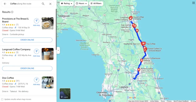
I can even tap the button to order online if I want. That’s pretty convenient.
What if you need to stop for gas instead? Maps will show you a list of gas stations on your route, along with gas prices.
Because these stops are already along your route, you don’t have to worry about going too far off course and rerouting your entire journey.
Waze also offers the option to add a stop, but Google Maps gives you more options and more information. Adding your new destination is hassle-free, and you can add up to 10 pit stops along the way.
If you want the fastest route: Tie
Want to reach your destination as fast as possible, with no regard for anything else? I couldn’t find much difference between the Waze app and Google Maps.
Sure, Waze is known for going all out to find the shortest route, even if that means sending you on a wild goose chase through winding, narrow side streets to get to your destination.
As Tom's Guide says, “Waze would tell you to drive through an active war zone to shave 5 seconds off your journey.”
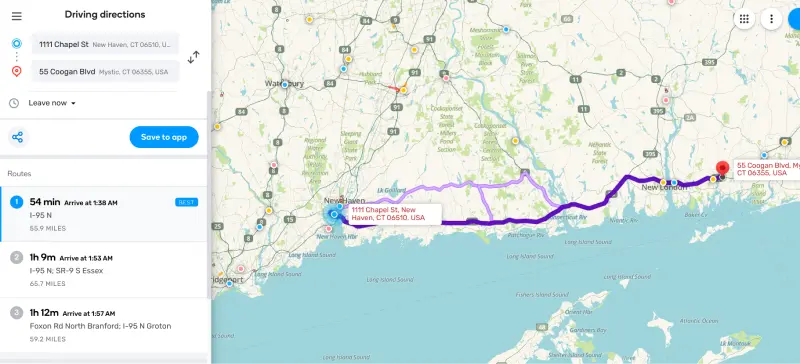
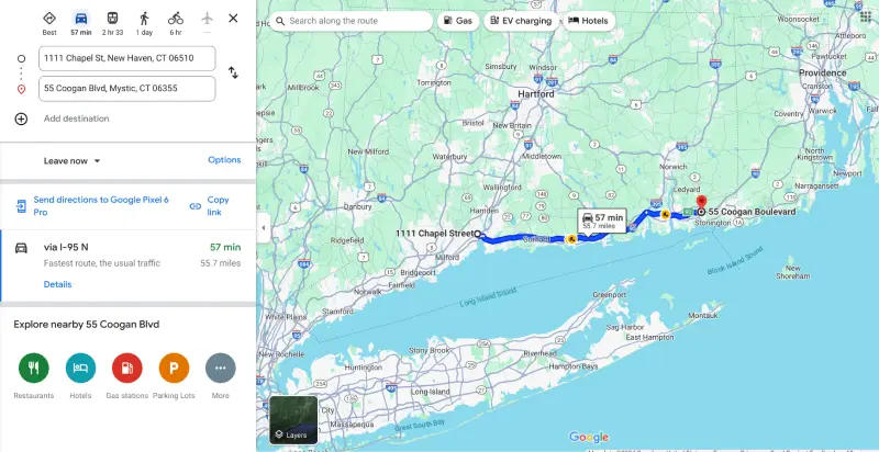
But in my tests, I couldn’t see much difference. For example:
- On a route through Connecticut from the Yale University Art Gallery to the Mystic Aquarium, Waze shaved a whole three minutes off the arrival time on an hour-long drive.
- On a trip from Chicago’s Fulton Market to Wrigley Field, the Google Maps route was one minute faster.
I suspect the difference only shows when things go wrong and there’s a crash along the route. That’s when Waze might use real-time updates or traffic information to get creative and send you on a wild alternative route.
But most of the time, Waze and Google Maps offer very similar ETAs.
If you want to take public transport: Google Maps
Public transportation is great, but it can also be confusing, especially if you’re in a new city and have to be somewhere at a certain time. In a lot of big cities, taking transit can be faster than driving!
Google Maps helps you navigate public transit with confidence, something Waze doesn’t do at all.
Just enter your starting point and destination, and choose public transportation as your mode of transport.
Google Maps will give you detailed walking directions and info on which subway route, train, or bus to take to reach your destination.
Let’s say I wanted to get from Grand Central Station in New York City to One World Trade Center. Maps tells me where to walk to reach the subway route I need to take. It also tells me how many stops until I reach my destination and what they are, so I don’t accidentally get off at the wrong stop.
That level of detail is exactly what you need when you’re trying to find your way around a big, chaotic city like New York.
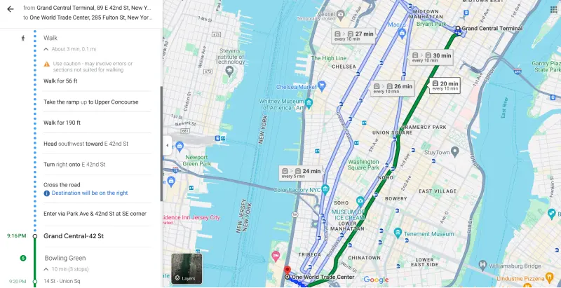
I also love that they include a link to tickets and information right at the bottom of the directions list. If you’re in a hurry and need to get somewhere, Maps can save you time and make things a little less stressful.
Google Maps isn’t the only app that offers public transport directions. Apple Maps can also help you get from one end of the city to the other on a bus, train, tram, or subway.
But unfortunately, this isn’t a feature that Waze has integrated into their platform.
So, if your goal is to use public transportation, Google Maps is the obvious choice.
If you want more detailed navigation directions: Waze
When you’re traveling on a busy highway in bumper-to-bumper traffic, the last thing you want is to find out you’re in the wrong lane and are about to miss your exit.
When you’re using Waze as your nav, this nightmare scenario is less likely to happen.
Why?
Because Waze has really detailed directions.
As one Redditor points out, Waze does a great job of making sure you’re always in the right lane. On their commute, there’s a four-lane highway with a junction in which the fourth rightmost lane turns into an exit.
Waze warns you about this change and tells you to stay in the first three lanes.
Maps, unfortunately, doesn’t warn about this and only shows the lanes you should be in if you need to take that exit.
For roundabouts, Waze wins here, too. The app will show you and tell you the exit number. Google Maps will tell you to exit, but there is no mention of it on-screen.
It’s the little details like this that can help you reach your destination faster and with less stress. In the details department, Waze also excels in other ways.
For example:
- It displays the correct speed limit on most roads
- It shows the precise price for tolls
Google Maps doesn’t always display the speed limit, and it will tell you that there are tolls — just not how much they cost.
So, if you’re off to somewhere new and anxious about getting there on time (or in one piece), you may appreciate Waze’s detailed navigation more than Google’s simpler approach.
If you want to customize your experience: Waze
Looking for a navigation app with robust customization options? Waze is your best option.
If you want to change your navigation voice, Waze has plenty of options for each country or region. They even have celebrity voices from time to time (most are temporary and only for promotional purposes).
Want to change your vehicle icon? You can do that, too. You can even change your mood, which other people can see on their own maps.
If you contribute enough to the Waze community, you can unlock special mood icons, like a golden crown or a T-rex.
Google Maps is a little disappointing when it comes to customization. You can switch your icon from the classic, boring arrow to one of three cheesy 3D cars. You can also change your navigation voice, but the options are more limited.
Customization isn’t everything, of course, but if it’s something that’s important to you, Waze will be your go-to option.
If you’re biking or walking: Google Maps
Google Maps offers something Waze doesn’t: directions for biking or walking.
In fact, Google’s map app will even combine driving and walking directions if it’s the fastest way to get somewhere.
Waze, on the other hand, is designed mainly for commuters (i.e., drivers on roadways). And they have no plans to support walking directions any time soon.
So, if you plan to explore a new city or just want to take a nice bike ride, using Google Maps is your best bet.
If you want to take your navigation offline: Google Maps
Do you like to go off the beaten path? Do you travel to remote areas where cell signals are as scarce as people?
If so, you need a navigation app that offers downloadable, offline maps to keep you on route even if you lose signal.
Here’s one area where Google Maps really shines.
One of the most beloved Maps features is the ability to download and use your directions offline.
At this time, Waze doesn’t support the use of offline maps. If you’re not connected to the internet, you won’t be able to find or navigate a route.
What about multi-route planning?
Google Maps and Waze are two of the most popular navigation apps. But when it comes to multi-route planning, neither of these platforms is ideal.
If you need to plan fast, efficient routes for multiple vehicles — say if you’re running a delivery business — you need a specialized solution like Routific.
Routific takes the guesswork and hard work out of route planning, so you can focus on more important things.
For everything else, you have Maps or Waze to help you get to your destination ASAP.
Frequently Asked Questions
Related articles
Liked this article? See below for more recommended reading!
How To Plan A Route With Multiple Stops In Apple Maps
How To Route With Multiple Stops On Google Maps
